San Antonio Tornado Damage
Confirmed Tornadoes Cause Damage Across San Antonio Area; No Injuries Reported
Anonymous
Key Points
1
Radar-confirmed tornado tracked northeast after crossing I-10 between The Dominion and Shavano Park, with on-the-ground video circulating showing the tornado in NW San Antonio as it moved toward The Rim.
2
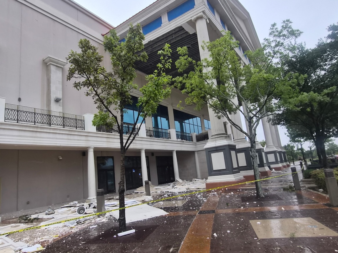
Early damage reports identified at the Palladium movie theater and Bass Pro Shop along I-10 at The Rim, in addition to an apartment complex on UTSA Boulevard with roof damage; there were no reported injuries at the time.
3
The National Weather Service issued a tornado warning for northwestern Bexar County and western Comal County that was in effect until 8:30 a.m., covering areas including The Dominion, Shavano Park, Cross Mountain, Leon Springs and Fair Oaks Ranch.
4
Officials urged residents to shelter immediately: move to a basement or interior room on the lowest floor, avoid windows, and seek substantial shelter if outdoors, in a mobile home, or in a vehicle.
5
A separate tornado warning for Frio and Medina counties was issued on July 16, with the storm over Frio Town moving north at about 15 mph; the warning extended to 7:15 a.m. and noted hazards such as hail up to pea size and wind gusts to 70 mph, alongside a rare Level 4 outlook for excessive rainfall west of San Antonio.
A tornado touched down in northwest San Antonio on the morning of July 15, causing damage along I-10 at The Rim shopping center and prompting urgent shelter orders for thousands of residents. San Antonio Report confirmed the National Weather Service tracked the twister moving northeast at about 20 mph after crossing I-10 between The Dominion and Shavano Park.
Damage was reported at the Palladium movie theater, Bass Pro Shop, and an apartment complex on UTSA Boulevard, though no injuries were reported at the time. SA Current described the destruction at The Rim as significant, with video of the tornado circulating on social media as it moved through the area.
Tornado Crosses I-10 and Hits The Rim
The National Weather Service confirmed the tornado formed near The Dominion and crossed I-10 before striking The Rim, a busy retail corridor on San Antonio's northwest side. Click2Houston reported that on-the-ground video caught the twister on camera as it moved through the area. The storm tracked northeast at roughly 20 mph.
Early damage assessments pointed to roof damage at the Santikos Palladium cinema and structural damage at Bass Pro Shop. SA Current said the damage at The Rim was significant. An apartment complex on UTSA Boulevard also suffered roof damage. Authorities confirmed no injuries in the immediate aftermath.
NWS Warning Covered Dozens of Northwest Communities
The National Weather Service issued a tornado warning for northwestern Bexar County and western Comal County, set to expire at 8:30 a.m. The warning covered The Dominion, Shavano Park, Cross Mountain, Leon Springs, Fair Oaks Ranch, and the Rim area along Loop 1604 and I-10.
San Antonio Report noted that debris and possible ground contact were reported during the storm. Officials told residents to move immediately to a basement or interior room on the lowest floor and stay away from windows. Anyone outdoors, in a mobile home, or in a vehicle was urged to find the nearest solid structure fast.
Second Warning Issued for Frio and Medina Counties
A separate tornado warning was issued on July 16 for Frio and Medina counties. Tribune-Review reported that a storm near Frio Town was moving north at about 15 mph. That warning ran until 7:15 a.m. and flagged hail up to pea size and wind gusts reaching 70 mph.
OAOA reported that slow-moving storms were soaking a wide stretch of South Texas. The region also faced a rare Level 4 high-risk outlook for excessive rainfall west of San Antonio. That rating signals a serious flood threat. Residents were urged to keep watching local weather updates as conditions continued to change.
Overnight Rain Adds to Flooding Risk Across Region
Before the tornado even touched down, San Antonio had already taken a hit. San Antonio Report said the city received 2 to 4 inches of rain overnight from a slow-moving storm system. That rain saturated the ground and raised the risk of flash flooding across the region.
The Level 4 excessive rainfall outlook — the highest tier — covered areas west of San Antonio. It signals conditions that can overwhelm drainage systems and flood roads quickly. Click2Houston noted that both tornado and flash flood warnings were active across the region at the same time, stretching emergency resources thin.
Sentiment
Mostly NegativeNEGATIVENEUTRALPOSITIVE
Publishers
37
Articles
50
Reach
87
Topics
A
AnonymousAuthor


