Tropical Storm Edouard
Tropical Storm Edouard Nears Gulf Coast Ahead of Expected Tuesday Landfall
Anonymous
Trending on XTropical Storm Edouard forms in Gulf of Mexico
Key Points
1
Storm Surge Warning is in effect from High Island, Texas to the Vermilion/Cameron Parish Line, and a Hurricane Watch is in place from High Island to Cameron, Louisiana, along with a Tropical Storm Warning for Port Bolivar to the Vermilion/Iberia Parish Line. The Storm Surge Warning specifically signifies a life-threatening inundation threat in the next 24 hours.
2
Forecasts indicate Edouard should reach the northwestern Gulf Coast within the warning area on Tuesday and move inland over southeast Texas Tuesday night, with strengthening likely to near-hurricane strength before landfall.
3
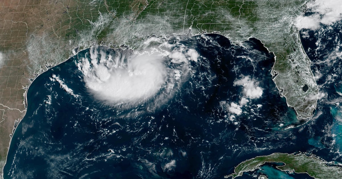
As of 11 p.m. Monday, Edouard was a tropical storm with maximum sustained winds of 40 mph, located about 125 miles southeast of Cameron, Louisiana, and 155 miles southeast of Port Arthur, Texas, moving west-northwest at about 7 mph.
4
Forecasters say Edouard’s intensity could swing due to environmental factors like wind shear; the system is in an environment with low shear and warm water, which can both restrain or enhance strengthening before landfall.
5
In addition to wind and surge risks, forecasters caution that tornadoes could occur as Edouard approaches the coast, with isolated tornado threats possible in the affected region.
Tropical Storm Edouard is racing toward the Texas-Louisiana coast and could reach near-hurricane strength before slamming ashore late Tuesday, National Hurricane Center warned. As of 11 p.m. Monday, Edouard packed 40 mph winds and sat 125 miles southeast of Cameron, Louisiana, moving west-northwest at 7 mph. Forecasters say the compact storm could intensify rapidly in warm Gulf waters before making landfall near the Sabine River region.
A Storm Surge Warning now covers High Island, Texas to Vermilion Parish, Louisiana, with life-threatening inundation possible in the next 24 hours. Travel and Tourism World reported that heavy rainfall and flash flooding are expected to affect southeastern Texas and southwestern Louisiana. The National Weather Service issued tropical-storm warnings and a hurricane watch, signaling damaging winds and significant rain are coming to the region.
Edouard Could Strengthen to Near-Hurricane Winds Before Landfall
The storm is moving through an environment with low wind shear and warm water — conditions that can fuel rapid intensification. Space City Weather meteorologist Eric Berger said impacts "should not be an extraordinary rainfall or flooding event," but National Hurricane Center forecasters warned that a last-minute pulse of organization could push winds near the 74 mph hurricane threshold. Edouard's exact strength at landfall remains uncertain due to these competing environmental factors.
Heavy Rain and Storm Surge Threaten Southeast Texas and Louisiana
Forecasters expect 3 to 6 inches of rain across the upper Texas coast, with isolated pockets seeing up to 9 inches — mostly east of Interstate 45. CBS Austin reported that Governor Greg Abbott's state agencies are tracking the storm's path toward Southeast Texas. Storm surge warnings mean 2 to 4 feet of life-threatening inundation is possible along the warning area from High Island to Vermilion Parish.
A flood watch is in effect for eastern Southeast Texas, where low-lying areas face the greatest risk of street and urban flooding. Head Topics reported that the storm threatens to disrupt travel and commerce across the Gulf Coast region on Tuesday and into Wednesday. Rough seas and coastal erosion are also expected as Edouard approaches.
Tropical-Storm Warnings and Tornado Risk Extend Inland
Coastal residents from Port Bolivar, Texas, to Vermilion Parish, Louisiana, are under tropical-storm warnings that include gusty winds and heavy downpours. AJC reported that Edouard formed in the Gulf and is expected to bring heavy rainfall and flooding to parts of Texas and Louisiana. Isolated tornado threats are also possible as the system moves ashore, adding to the hazards residents should prepare for.
The National Weather Service urged residents to take all necessary actions to protect life and property before the storm arrives. Edouard is the fifth named storm of the 2026 Atlantic hurricane season. The compact system developed rapidly over abnormally warm Gulf waters, leaving coastal communities with less than 24 hours of advance warning before tropical-storm-force conditions arrive.
Local Forecasters Urge Calm Despite Serious Hazard Warnings
While national alerts emphasize life-threatening risks, local Texas meteorologists stress that for the broader Houston area, Edouard will be a fast-moving rainmaker rather than a catastrophic event. Eric Berger noted that panic-buying and extreme precautions are unnecessary. Power outages and localized highway flooding are likely, but the storm does not pose the risk of a major disaster for most residents in the region.
Sentiment
Mostly PositiveNEGATIVENEUTRALPOSITIVE
Publishers
49
Articles
268
Reach
317
Topics
A
AnonymousAuthor


