Tropical Activity Rises
Tropical Storm Cristobal Fades in Atlantic; Invest 92L Eyes Caribbean While Pacific System Forms
Key Points
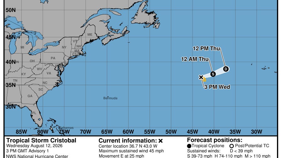
Cristobal formed from Invest 93L and the National Hurricane Center began advisories at 10 a.m. after satellites showed a better-defined circulation, with maximum winds near 45 mph about 880 miles west of the Azores.
Environmental conditions around Cristobal include sea-surface temperatures around 77°F, which are only marginally favorable, with expected cooling waters, drier air and stronger wind shear that should lead to weakening and dissipation by Thursday.
Forecasters say a developing disturbance in the Pacific near Hawaii could become a tropical depression or storm within the next day or so and potentially affect Hawaii later this week, illustrating the broader El Niño‑related activity in the basin.
Forecast guidance includes scenarios where systems lift north of the Lesser Antilles to avoid the core of higher wind shear, with some models indicating a northward tilt before reaching the Caribbean.
In the Central Pacific, the National Hurricane Center is expected to begin advisories on a system dubbed Potential Tropical Cyclone One-C, located about 1,000 miles east-southeast of Hawaii.
Tropical Storm Cristobal became the third named storm of the 2026 Atlantic hurricane season on August 12, with maximum sustained winds near 45 mph and a location about 880 miles west of the Azores, according to Houston Chronicle. The storm poses no threat to land, and there are no coastal watches or warnings in effect.
Cristobal is expected to weaken quickly and dissipate by Thursday as it encounters cooler waters and hostile conditions. Meanwhile, forecasters are watching a separate disturbance, Invest 92L, which carries an 80% chance of development and could push toward the Caribbean this weekend, TC Palm reported.
Cristobal Forms Far From Florida, Fades Fast
The National Hurricane Center issued its first advisory on Cristobal at 11 a.m. ET on August 12 after satellites showed a better-defined circulation, Herald Tribune reported. The storm formed from what forecasters had been tracking as Invest 93L in the central subtropical Atlantic.
Conditions around Cristobal are only marginally favorable. Sea-surface temperatures sit near 77°F — just barely warm enough to support a tropical storm. Drier air, cooler waters ahead, and stronger wind shear are all expected to tear the storm apart before Thursday, according to Houston Chronicle.
Invest 92L Targets the Caribbean This Weekend
While Cristobal fades, a more consequential system is brewing. Invest 92L carries an 80% chance of tropical development and is forecast to track toward the Lesser Antilles this weekend, TC Palm reported. Forecasters are watching it closely as the peak of hurricane season approaches.
Some forecast models show systems in this area lifting northward before reaching the Caribbean core, skirting the zone of higher wind shear. If Invest 92L strengthens into a named storm, it would be called Dolly — the fourth name on the 2026 Atlantic list.
A Quieter Atlantic Season Tied to El Niño
The 2026 Atlantic season has been slower than recent years. Forecasters attribute this largely to El Niño, which increases upper-level wind shear across the Atlantic basin and suppresses storm development. Only three named storms have formed as of mid-August.
A separate tropical wave off the West African coast carries about a 30% chance of development over the next seven days, Houston Chronicle reported. That system would need to track westward across the Atlantic before posing any threat to land.
Pacific Also Active: Hawaii Could See Tropical Threat
The Atlantic is not the only basin in focus. A disturbance near Hawaii in the Central Pacific could become a tropical depression or storm within days, TC Palm reported. The National Hurricane Center was expected to begin advisories on the system, dubbed Potential Tropical Cyclone One-C, located about 1,000 miles east-southeast of Hawaii.
The broader activity across multiple basins reflects the complex weather patterns typical of mid-August. Forecasters say peak Atlantic hurricane season runs through mid-October, meaning conditions could still shift significantly in the weeks ahead.
Sentiment
Mostly NegativePublishers
33
Articles
240
Reach
273


