Tropical Depression Threatens Gulf
Tropical Depression Two Forms in Gulf, Expected to Strengthen into Bertha, Bringing Rain to Coast
Anonymous
Key Points
1
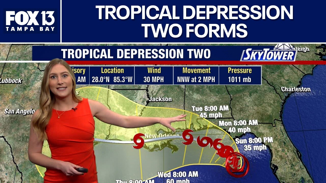
As of the 11 a.m. EDT advisory, the center of Tropical Depression Two was about 155 miles south of Panama City, Florida, with maximum sustained winds near 30 mph and a north-northwest motion of about 2 mph.
2
Forecasts indicate the system will move slowly along the northern Gulf Coast for the next couple of days before turning west later this week, with the center expected to remain offshore as it strengthens.
3
Storm surge of 1 to 3 feet is possible near the coast, with the deepest water expected along the immediate coast between Indian Pass and Chassahowitzka, Florida.
4
Tropical Storm Watch is in effect for the Forgotten Coast region (mouth of the Ochlockonee River westward) and Tropical Storm Warnings are in place for the waters of Apalachee Bay beyond 20 nautical miles from the coast.
A tropical depression has formed in the northern Gulf of Mexico and is expected to become Tropical Storm Bertha within days. As of the 11 a.m. EDT advisory, the center of Tropical Depression Two sat about 155 miles south of Panama City, Florida, crawling north-northwest at just 2 mph with maximum sustained winds near 30 mph, according to My Suncoast.
Parts of the Florida Panhandle are already under a Tropical Storm Watch, Yahoo News reported. Forecasters warn the slow-moving storm will bring heavy rain, dangerous flooding, and a coastal storm surge before it turns west later this week.
Tropical Storm Bertha Could Form Within Days
The National Hurricane Center upgraded the system to Tropical Depression Two after it developed a well-defined circulation, WLOS reported. Forecasters expect it to strengthen into Tropical Storm Bertha as it drifts slowly along the northern Gulf Coast. The track remains uncertain. A shift in course could move the worst impacts to different areas.
The system is expected to stay offshore as it strengthens over the next day or two. After that, forecasters predict it will turn west later this week. Residents from western Florida to Louisiana are in the zone of potential impact, WFTV noted.
Tropical Storm Watches Cover Florida Panhandle Coast
A Tropical Storm Watch is in effect for the Forgotten Coast region, stretching from the mouth of the Ochlockonee River westward to the Alabama border, according to Yahoo News. That covers a stretch of coastline known for shallow bays and low-lying land that is especially vulnerable to storm surge.
Tropical Storm Warnings are in place for Apalachee Bay waters beyond 20 nautical miles from shore. The deepest storm surge — between 1 and 3 feet — is expected along the immediate coast between Indian Pass and Chassahowitzka, Florida, My Suncoast reported.
Heavy Rain and Flash Flooding Are the Biggest Threats
Rainfall totals of 2 to 4 inches are expected across the central Gulf Coast. Isolated spots could see up to 8 inches. Flash flooding is the greatest danger, especially in urban areas where water cannot drain fast enough, WLOS reported.
Rain impacts could stretch inland into Georgia, though North Georgia faces minimal direct effects. Forecasters say the slow forward speed of the storm — just 2 mph — will allow rain to pile up in the same areas for an extended period. That makes flooding worse even without extreme wind speeds.
What Residents Should Do Before the Storm Arrives
Forecasters urge people along the Gulf Coast to monitor updates closely as the storm's track could still shift. Even a small change in direction could move the worst rain and surge to a different part of the coast. Emergency plans should be ready now, before conditions worsen.
Storm surge of 1 to 3 feet may sound small, but even a foot of fast-moving water can knock a person down. Coastal residents should know their evacuation routes and avoid low-lying roads during heavy rain, Fox 13 News noted.
Sentiment
Mostly NegativeNEGATIVENEUTRALPOSITIVE
Publishers
18
Articles
11
Reach
29
Topics
A
AnonymousAuthor


