No Tropical Threat
National Hurricane Center: No Tropical Cyclones Expected This Week, Florida Endures Triple-Digit Heat
Anonymous
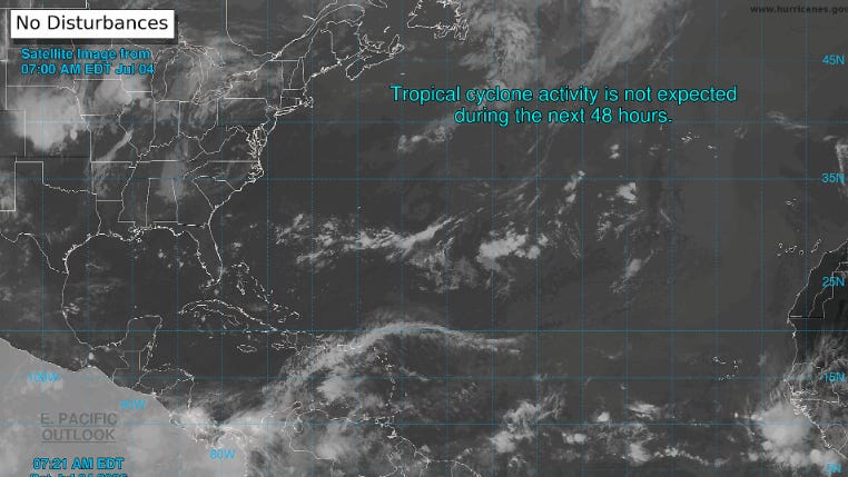
The National Hurricane Center says no tropical cyclones will form this Fourth of July — or for the next seven days — in the North Atlantic, Caribbean, or Gulf of Mexico, according to Tallahassee Democrat. Americans celebrating outdoors can breathe easy on that front. But Floridians still face a dangerous heat threat, with heat index values expected to climb into the triple digits.
The NHC is currently tracking three tropical waves in the Atlantic basin. None of them pose a threat to Florida or the United States, Naples Daily News reported. The Atlantic hurricane season runs from June 1 through November 30, with peak activity between mid-August and mid-October — meaning the busiest stretch still lies ahead.
Three Tropical Waves Tracked But No Danger Yet
The NHC is keeping an eye on three separate tropical waves moving across the Atlantic. A tropical wave is a westward-moving area of disturbed weather that can sometimes develop into a storm. Right now, forecasters say none of these waves show signs of organizing into a tropical cyclone, according to Herald Tribune.
The seven-day outlook gives all three waves a low chance of development. That means holiday weekend plans along the Gulf Coast and Florida coastlines face no hurricane or tropical storm risk, The Ledger reported. Forecasters will continue to monitor the waves as they move westward across the basin.
Florida Faces Triple-Digit Heat Index This Holiday
While storms are not a concern, dangerous heat is. Heat index values — which combine temperature and humidity to show how hot it actually feels — are expected to top 100 degrees across Florida this Fourth of July, according to News-Press. High humidity makes the heat feel even more intense than the thermometer shows.
Residents and holiday crowds are urged to stay hydrated, limit time outdoors during peak afternoon hours, and seek air-conditioned spaces when possible. Heat-related illness can set in quickly under these conditions, especially for children and the elderly, NWF Daily News noted.
Peak Hurricane Season Still Months Away
Early July is historically a quiet time for Atlantic hurricane activity. The season officially opened June 1 and runs through November 30. But the most dangerous stretch — mid-August through mid-October — has not yet arrived, according to Herald Tribune. Forecasters warn that activity will only increase as summer deepens.
Climate patterns this year have kept early-season storm formation suppressed. However, warm Atlantic sea surface temperatures remain a key ingredient for storm development later in the season. Residents in hurricane-prone areas should use the current quiet period to review emergency plans and stock supplies, Naples Daily News reported.
What to Watch as the Season Ramps Up
The NHC issues tropical weather outlooks twice daily during hurricane season. These outlooks assign a percentage chance of development to any disturbance showing signs of organization. Right now, all three tracked waves carry low formation odds, The Ledger reported. But that can change quickly as conditions evolve.
Forecasters recommend checking NHC updates regularly through the summer. The agency monitors the entire Atlantic basin — from the African coast to the Gulf of Mexico. With peak season still weeks away, now is the time to prepare, not wait, according to Tallahassee Democrat.
Sentiment
NeutralNEGATIVENEUTRALPOSITIVE
Publishers
6
Articles
5
Reach
6
Topics
A
AnonymousAuthor


