Heat, Humidity, Storms Expected Across Regions
Heat, Humidity, Storms Expected Across Regions
Anonymous
Key Points
1
In the Quad Cities, the heat index could approach 95 to 100 degrees Tuesday despite air temperatures in the upper 80s to low 90s.
2
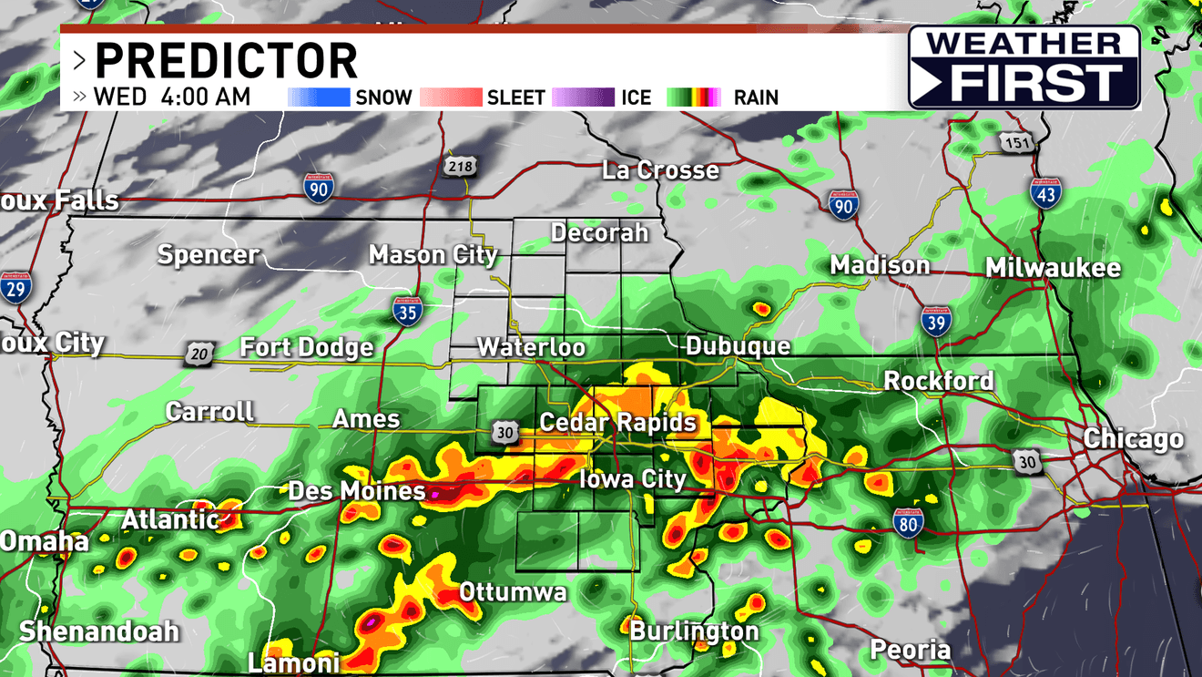
KWQC issued a First Alert Day from Tuesday evening through Wednesday morning because of the potential for flooding in northern counties; the Weather Prediction Center placed northern parts of the Quad Cities under a Level 2 of 4 Slight Risk for flash flooding.
3
The Quad Cities forecast calls for a Level 1 of 5 risk of strong to severe storms, mainly north and west of the metro area, with gusty winds and hail possible.
4
In the central Illinois forecast area, the Storm Prediction Center has issued a Level 1 risk for storms, with strong winds and pockets of heavy rain identified as the primary concerns; storms are expected to wrap up early Thursday morning.
5
South Georgia is expected to remain near 90 degrees through Thursday, with no washout anticipated even as scattered to numerous afternoon and evening showers and thunderstorms become more likely along the lingering front.
A comfortable stretch ends Tuesday as heat and humidity surge back across multiple regions, with highs reaching the upper 80s to low 90s. A cold front will trigger showers and thunderstorms from late Tuesday through Wednesday, with Eastern Iowa and the Quad Cities facing the greatest risk of heavy rain, localized flooding, and rainfall totals between 1 to 3 inches CBS2Iowa, particularly north of Interstate 80.
In the Quad Cities, the heat index could approach 95 to 100 degrees Tuesday despite air temperatures in the upper 80s to low 90s KWQC. The Weather Prediction Center placed northern parts of the Quad Cities under a Level 2 of 4 Slight Risk for flash flooding, prompting a First Alert Day from Tuesday evening through Wednesday morning.
Quad Cities Braces for Flooding and Strong Storms
Eastern Iowa and the Quad Cities face the most dangerous weather Tuesday night into Wednesday. Heavy downpours could produce 1 to 3 inches of rainfall, with the highest risk north of Interstate 80 and south of Highway 20 CBS2Iowa. Localized flooding is likely in these areas.
The Quad Cities forecast shows a Level 1 of 5 risk for strong to severe storms, mainly north and west of the metro area Fox8. Isolated strong winds and hail are possible. Meanwhile, central Illinois faces a Level 1 storm risk from the Storm Prediction Center, with strong winds and heavy rain pockets as the primary concerns. Storms should wrap up early Thursday morning.
Heat Index Climbs Before Front Arrives
Tuesday brings oppressive humidity to the Quad Cities, pushing the heat index toward 95 to 100 degrees despite air temperatures only in the upper 80s to low 90s KWQC. This spike in temperature and moisture arrives just hours before the cold front triggers rain and thunderstorms late in the day.
South Georgia Remains Warm With Scattered Storms
South Georgia will stay near 90 degrees through Thursday as scattered to numerous afternoon and evening storms develop along a lingering front WALB. The best chances for rain are expected east of Interstate 75 and close to the Florida-Georgia border. No washout is anticipated, but showers and storms should increase from Wednesday through Saturday.
Cooler, Milder Weather Returns by Week's End
Following the frontal passage, cooler and milder air will move into the Midwest by late Wednesday and Thursday. Temperatures will drop back into the 70s and 80s across parts of the region CBS2Iowa. Rain chances will gradually ease as the week progresses, bringing relief from both the heat and storm threats.
Sentiment
Mostly NegativeNEGATIVENEUTRALPOSITIVE
Publishers
28
Articles
6
Reach
34
A
AnonymousAuthor


